
LNU Lightning Complex: Dry Creek Valley Residents On Edge As New Weather Threat Closes In
KPIX5 CBS
HEALDSBURG (CBS SF) – People who live in the foothills and Dry Creek Valley outside Healdsburg were nervously awaiting the arrival of a new weather threat Sunday night.
The horizon was filled with the smoke from last week’s dry lightning storms that sparked the massive Walbridge Fire. The National Weather Service has issued a Red Flag Fire Warning for the area until 5 p.m. Monday.
A plume of unstable weather from the remnants of Hurricane Genevieve was streaming into the region, bringing with it gusty winds and dry lightning.
“Elevated moisture and instability from former Hurricane Genevieve will move over the region this weekend through early next week and bring the threat of elevated thunderstorms across much of Northern California,” the National Weather Service warned. “A low pressure system off the coast may enhance and strengthen these thunderstorms allowing some to develop frequent lighting strikes and gusty erratic outflow winds.”
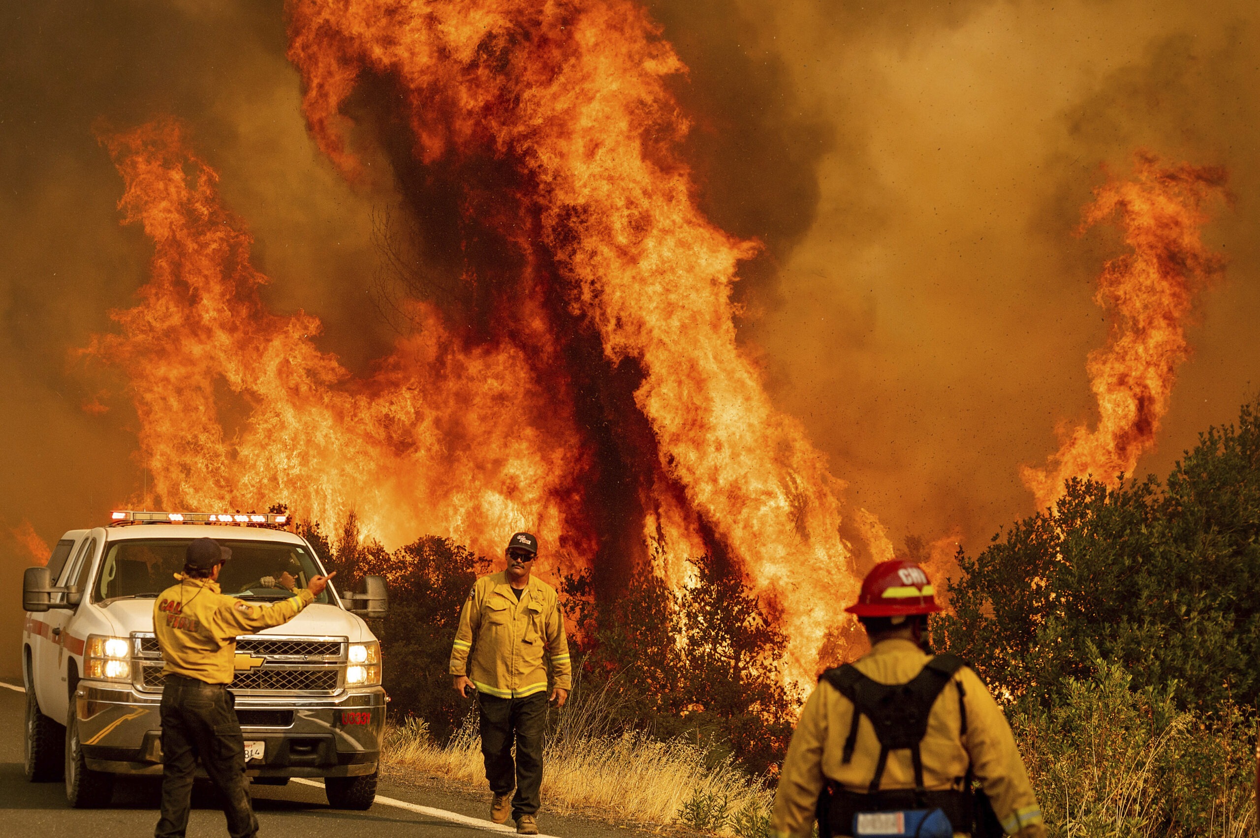
The threat of new fires and the expansion of those already burning was not lost on Elliott Doss, who has lived in Dry Creek for almost 30 years and built his home on the weekends with his own two hands.
“I set up Rainbirds up on both the roofs,” Doss told KPIX 5. “I’m not supposed to be here, but I’m saving my home, I hope,” says Doss.
Doss has set up a complex system of sprinklers and hoses to try to keep the entire property wet. He questions whether there will be enough firefighters to save every structure.
Sunday afternoon engine crews from as far away as Seattle were helping with structure defense near Dry Creek. Firefighters were using chainsaws to clear brush and raking leaves from buildings that could be at risk.
At the same time three Air National Guard helicopters with 660 gallon water buckets made round trips back and forth from a pond in Dry Creek to the fire lines on the hills. The goal is to shore up containment lines ahead of Sunday night’s storms.
“The last thing we’re going to need anywhere, not just here but anywhere in the state, will be new fires to take off. That will be another strain on resources,” said a CalFire representative during a press conference earlier in the day Sunday.
Fire officials made it clear the focus overnight Sunday into Monday will be to quickly attack any new fires caused by the forecasted thunder storms.
“If we do get a new start, we have to pull resources. That is very difficult to do, but we have to do it. We have to make sure we don’t have new starts up and running on us,” Cal Fire officials said.
It’s something that worries Gerry and Jann Forth. They say the fire is burning less than half a mile from their home and vineyard.
“As winemakers, of course, we are worried about the grapes,” Gerry Forth told KPIX 5. “We haven’t picked anything this year.”
The Forths say there is a real possibility they could lose not only their home, but also their livelihood.
“It is terrifying,” Gerry Forth said. “I can’t even express it.”
Elsewhere, firefighters were battling the complex fires to the north where it was roaring into Lake County.
Flames from the LNU Lightning Complex fires leap above Butts Canyon Road on Sunday, Aug. 23, 2020, as firefighters work to contain the blaze in unincorporated Lake County, Calif. (AP Photo/Noah Berger)
Cal Fire officials said they’ve pre-positioned some engines and other resources Sunday night to be available to quickly jump on any new start fires, wherever they happen.
The massive LNU Lightning Complex in the North Bay had burned 347,630 acres by Sunday night or 533 square miles, an area more than 11 times the size of San Francisco. It is California’s second largest wildfire on record.
The complex fires have destroyed 871 homes and structures and damaged another 234.
“Significant fire growth is expected throughout the rest of the operational period,” the agency said in its morning statement. “Extreme fire behavior with short and long range spotting are continuing to challenge firefighting efforts. Fires continue to make runs in multiple directions and impacting multiple communities.”
At a briefing Sunday morning, Cal Fire incident commander Sean Kavanaugh said 1,704 personnel have been assigned to the LNU fire, including 233 engines. More than three dozen engines from Washington State and Oregon are aiding in the firefight.
The largest portion is the Hennessey Fire burning in Lake and Napa counties. In that fire, 287,811 acres (449 square miles) have burned and containment is at 17 percent.
CALIFORNIA WILDFIRES COVERAGE
- CZU Lightning Complex: Cal Fire Says Looter Stole Fire Commander’s Wallet, Drained Bank Account
- LNU Lightning Complex: Shifting Wind Pushes Walbridge Fire Toward North Bay Communities
- CZU Lighting Complex: More Than 77,000 Driven From Threatened Homes; Video: Big Basin State Park Devastated By Flames
- SCU Lightning Complex: New Evacuation Order; Complex Grows To More Than 340,000 Acres
- Red Flag Warning Issued for Fire-Ravaged Northern California
- LNU Lightning Complex: Areas Of Healdsburg, Lake County Among Latest Evacuations Ordered
In Sonoma County, the Walbridge fire continues to threaten numerous communities west of Healdsburg, burning 51,072 acres and is five percent contained.
Meanwhile, the Meyers Fire burning north of Jenner has burned 2,360 acres and is 70 percent contained. Battalion Chief Chris Waters said reopening Highway 1 and repopulation of evacuated areas could happen within 24-48 hours.
At Sunday morning’s briefing, Waters noted the numerous challenges in battling the Walbridge fire.
“Extremely difficult conditions for fire suppression; very steep river canyon terrain, redwood fuels, very few places to really operate efficiently and lots and lots of structures constructed in the fire area,” Waters said.
Kavanaugh said getting a handle on any new fires from another round of lightning must be a priority.
“The last thing we’re going to need anywhere, not just here, but anywhere in this state is new fires to take off. That will be another strain on resources,” he said.
Kavanaugh also noted that the LNU complex, and the SCU Lightning Complex burning to the south have collectively burned more than 680,000 acres and are the 2nd and 3rd largest wildfires in California history.
LNU Lightning Complex Wildfires Burn Zones Map & Evacuations
NAPA COUNTY EVACUATION ORDERS
- Highway 128 from Lower Chiles Valley Road to Monticello Road
- Highway 128 from Chiles Pope Valley Road to Lower Chiles Valley Road
- Chiles Pope Valley Road from Highway 128 to Lower Chiles Valley Road
- All of Hennessey Ridge Road.
- From Moskowite Corner to Wooden Valley Rd, Including the community of Circle Oaks
- Atlas Peak from the Bubbing Well Pet Cemetary at 2462 Atlas Peak Rd to the dead end
- From Loma Vista Rd / Soda Canyon Rd to the dead end.
- All of Steele Canyon Rd from Hwy 128 to and including the Berryessa Highlands Sub Divison
- Wragg Canyon Rd – from Hwy 128 to the end of the road, including Pleasure Cove Resort
- Chiles Pope Valley Road – From Lower Chiles Valley Road to Pope Canyon Road
- Highway 121 (Monticello Road) – from Wooden Valley Road to Silveraldo Trail
- Pope Valley Road – From Aetna Springs Road to Chiles Pope Valley Road
- Aetna Springs Road – From Pope Valley to the dead end
- Butts Canyon Road – From Aetna Springs Road to the Lake County Line
- James Creek Road – From Butts Canyon Road to the dead end
- Ink Grade – from Pope Valley Rd to White Cottage Rd
- Howell Mountain Rd – From Pope Valley Rd to White Cottage Rd
- Highway 121 (Monticello Road) – from Wooden Valley Road to Vichy Ave.
- Community of Angwin
- Community of Deer Park
- St Helena Hospital
- East side of HWY 29 from Lake County line down to Silverado Trail
- East side of Silverado Trail from Highway 29 to Highway 128
- Northwest side of Highway 128 to Chiles Pope Valley Road
- Northwest side of Chiles Pope Valley Road to Pope Valley Road
- Northwest side of Pope Valley Road to Butts Canyon Road
- West side of Butts Canyon to Lake County
SONOMA COUNTY EVACUATION ORDERS
- North of Austin Creek Recreational Area
- East of The Cedars
- Mill Creek Road west of the intersection of Puccioni Road
- South of Stewarts Point Skaggs Springs Road
- South of Stewarts Point Skaggs Springs Road
- West of West Dry Creek Road and Westside Road
- North of Sweetwater Springs Road and McCray Ridge Road
- East of the East Austin Creek (the actual creek)
Evacuation Zone – 2K2
- All areas west of Hwy. 101 East of the Russian River to the Windsor Town limits North of where Windsor River Rd. dead ends extending west to the Russian River
Evacuation Zone – 4A1
- All areas East of the Russian River
- North of River Rd.
- West of Trenton Healdsburg Rd. and Eastside Rd.
- South of the area between the western dead end of Windsor River Rd. and the Russian River
Evacuation Zone – 4C1
- North of Guerneville Road
- East of Covey Road and Hwy 116
- West of Laguna Rd
- South of River Road
City of Healdsburg
- The residents in the City of Healdsburg West of Highway 101 off of Chiquita Road are under an Evacuation Order. This includes Chateau Real, Matteri Rd, Burgundy Rd, Chablis Rd, Zinfandel Rd, and Riesling Rd.
- All areas in the city of Healdsburg East of Highway 101 remain on an Evacuation Warning.
SONOMA COUNTY EVACUATION WARNINGS
- West of Meyers Grade Road to the coast
- South of Fort Ross Road
- North of Russian Gulch State Beach
- North of Austin Cree Recreational Area
- East of Cedars
- West of Mill Creek Rd
- South of Stewarts Point-Skaggs Spring Road
Evacuation Zone – 2F1 — downgraded Sunday to warning
- East of Dutcher Creek Road and the Dry Creek (the actual creek)
- North of Canyon Road
- West of Hwy 101
Evacuation Zone – 2F2 — downgraded Sunday to warning<
- South of Canyon Road
- East of the Dry Creek (the actual creek)
- North of Lytton Springs Road
- West of Geyserville Avenue
Evacuation Zone – 2F3 — downgraded Sunday to warning
- South of Lytton Springs Road
- East of the Dry Creek (the actual creek)
- North of Westside Road
- West of the Healdsburg city limits.
Evacuation Zone – 2K1 — downgraded Sunday to warning
- All areas North and East of Westside Rd.
- West of Hwy. 101
- West of the Russian River
Meyers Fire – County Evacuation Zone 1F1
- All areas east of Bohemian Hwy.
- North of Graton Rd. and Harrison Grade Rd.
- West of Harrison Grade Rd., Green Valley Rd., and Hwy. 116
- South of the Russian River
Meyers Fire – County Evacuation Zone 1F2
- All areas south of the Russian River
- East and North of Hwy. 116 (Pocket Canyon)
- West of Martinelli Rd
Walbridge Fire – County Evacuation Zone 4A1
- All areas East of the Russian River
- North of River Rd.
- West of Trenton Healdsburg Rd. and Eastside Rd.
- South of the area between the western dead end of Windsor River Rd. and the Russian River
Walbridge – Evacuation Zone 4B1 (Northern Forestville)
- All areas south of River Rd. from Martinelli Rd. to Trenton Rd.
- West of Covey Rd.
- North of Front St. / Hwy. 116
- East of Martinelli Rd.
Walbridge – Evacuation Zone 2K2
- All areas south of Hwy. 101
- East of the Russian River to the Windsor Town limits
- North of where Windsor River Rd. dead ends extending west to the Russian River.
Meyers – Evacuation Zone 1E3
- All areas south of the Russian River
- West of Bohemian Hwy.
- North and East of Coleman valley Rd. and Willow Creek Rd.
Meyers – Evacuation Zone 1E1
- All areas south and west of Willow Creek Rd.
- North of Coleman Valley Rd. and Wright Hill Rd.
- East of the California Coastal National Monument (BLM property)
Meyers – Evacuation Zone – 1C1
- All areas east of the Sonoma coast to the south fork of the Gualala River. South of Kruse Ranch Rd. and Howser Bridge Rd. to Fort Ross Rd.
Evacuation Zone – 2A3
- North of Stewarts Point Skaggs Springs Road to the eastern edge of Lake Sonoma
- Everything west of the eastern edge of Lake Sonoma to the western boundary that runs north along the ridge line from the intersection of Stewarts Point Skaggs Springs Rd @ Old Stewarts Point Skaggs Springs Road to the interception of Rockpile Road @ Cooley Ranch Road north to the Mendocino County Line
Evacuation Zone 4B1
- All areas south of River Rd. from Martinelli Rd. to the intersection of River Rd at
- Trenton Rd.
- West of Covey Rd.
- North of Front St. / Hwy. 116
- East of Martinelli Rd.
Evacuation Zone – 4A2
- East of Trenton Healdsburd Road
- North of Mark West Station Road
- West of the Windsor City Limits and Windsor Road
- South of Windsor River Road
Evacuation Zone – 4A3
- East of Trenton Healdsburg Road
- North of River Road
- West of Slusser Road
- South of Mark West Station Road
Evacuation Zone – 2A2
- North of the Dry Creek and the norther fork of Lak Sonoma County
- West of Dutcher Creek, City of Coverdale city limits and Hwy 128
- South of the Mendocino County line
Evacuation Zone – 2C4
- South and West of Asti Road
- East of Hwy 101
- North of Hwy 128
Evacuation Zone – 2G1
- East of Hwy 101
- South and West of Hwy 128
- North of Alexander Valley Road
Town of Windsor Zone A
- North of Windsor River Road
- West of Hwy 101
- All to the Western and northern town limits west of 101
LAKE COUNTY EVACUATION ORDERS
The Lake County Sheriff’s Office has issued an EVACUATION ORDER for residents living in and around Hidden Valley Lake and Jerusalem Valley areas of Lake County due to a Wildland Fire. This includes residents living North of Butts Canyon Rd, South of Hofacker Ln to Morgan Valley Rd, East of Hwy. 29 and West of the Lake/Napa County line. Residents are advised that there is an IMMEDIATE threat to life and property from a wildfire, and are urged to evacuate. Please leave the area. If you are in need of shelter please proceed to a Temporary Evacuation Point (TEP) that has been setup at the old airstrip off of Hwy 53 in Clearlake. You are asked to stay in your vehicle and wear masks when you arrive at the TEP. A shelter is being established and you will be directed to the shelter by staff at the TEP.
- Eastside of Highway 29 – North of the Napa/Lake County line up to the Southern Intersection of Highway 29 / St Helena Creek Road (Across from the Twin Pine Casino)
- All of St Helena Creek Road – to the Highway 29 / St Helena Creek Road / Butts Canyon Intersection
- All areas and residents North and South of Morgan Valley Road (north of the previously established evacuation line (08/19/20) (from SR-29 and Hofacker Lane to Morgan Valley Road)
- East of Sky High Ridge Road (extending north to SR-20), South of SR-20, and West of the Lake County line
- The Lake County Sheriff’s Office has issued an EVACUATION ORDER for residents living in the following areas: All residents living south of Morgan Valley Rd., west of the Mandatory Evacuation boarder line at Sky High Ridge Rd. to HWY 29 and HWY 53 in Lower Lake. East of HWY 29 at Hofacker Ln. to the Mandatory Evacuation Boarder line. This area was previously under a warning and has been upgraded to an order.
LAKE COUNTY EVACUATION WARNINGS
- All areas west of Highway 29 (including areas west of Saint Helena creek Rd.)
- North and East of the Lake/Napa County Line (extending north to the Anderson Springs Rd. continuing between the County Line and Highway 175)
- South of Anderson Springs Rd, Neft Rd., and the Boggs Mountain Demonstration State Park
- Area prolongation to the intersection of Hofacker Ln. and SR-29
- This includes Middletown proper
- All areas and residents along Morgan Valley Road between Rocky Creek Road and Reiff Road
- All residences along and east of Big Canyon Rd., Perini Rd., and Seigler Canyon Rd., South of SR-29, west of SR-29, and north of the warning line (08/21/20)(Anderson Springs Rd., Neft Rd., and Boggs Mt Rec Area extending northeast to the intersection of SR-29 / Hofacker Rd.)
- We are asking everyone to take preparations in the event that an Evacuation Order is issued. Preparations should include gathering all medications, important documents, making plans for pets, and notifying family members where you may be going. Those requiring additional time to evacuate or those with pets or livestock should leave the area as soon as possible. During a mandatory evacuation, it will be extremely hectic and traffic conditions will be very congested. By evacuating early, you do your part in keeping yourself, your neighbors, and our first responders safe. Should an evacuation order be issued and shelter is needed, you will be directed to a Temporary Evacuation Point (TEP).
EVACUATION CENTERS
Napa County:
Crosswalk Community Church
2590 First Street
Napa, CA 94558
Sonoma County:
Temporary Evacuation Point
Santa Rosa Fair Grounds
1350 Bennett Valley Road
Santa Rosa, CA 95404
Petaluma Veterans Building
1094 Petaluma Blvd
South Petaluma, CA 94952
Lake County:
Temporary Evacuation Points: Is setup at the old airstrip off of Hwy 53 in Clearlake
Solano County:
- All Evacuation Centers in Solano County are closed
Animal Evacuation Centers:
Napa County Animal Shelter
942 Hartle Court
Napa, CA 94559
Valley Brook Equestrian Center 1132 El Centro Ave. Napa 55 horses
Napa Valley Horseman’s Association, 1200 Foster Road Napa 61 horses
Ag 4 Youth 1200 Foster Rd, Napa 62 Ruminants
Solano County
- Vallejo Fairgrounds, 900 Fairgrounds Drive, Vallejo (large animals, current count 211 animals)
- Solano County Animal Shelter, 2510 Claybank Rd (small animals only, current count 285 animals)