
Tropical Storm Eta “Regains Strength” With South Florida In Path
ZeroHedge.com
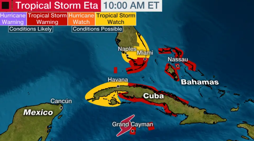
As of the 1000 ET advisory from the National Hurricane Center (NHC), Tropical Storm Eta “regained strength” as it traverses the northwestern Caribbean Sea and will pass over or near Cuba, the Bahamas, and South Florida this weekend into early next week, bringing torrential rains, high winds, and potentially dangerous storm surge.
Eta has 40 mph maximum sustained winds and is moving northeast at 17 mph. The storm’s location is about 45 miles west-northwest of Grand Cayman.

Tropical storm warnings have been issued for Cayman Islands, Cuba, and the northwestern Bahamas islands, including Abacos, Grand Bahama Island, and Nassau. NHC expects tropical storm conditions in those areas this weekend.
After Cuba, the storm is expected to curve towards the Gulf of Mexico, potentially passing over or near South Florida. Tropical storm warnings have been issued for much of South Florida.
“Gradual strengthening is expected over the Caribbean Sea before Tropical Storm Eta reaches Cuba, but some vertical wind shear and dry air may limit its intensification,” said The Weather Channel.
The Miami office of the National Weather Service forecasts rainfall totals for South Florida could range between 10 to 15 inches through Wednesday.

South Florida will start to experience Eta’s tropical-storm-force winds as early as Sunday evening.

As readers may recall, Eta has ravaged Central America, triggering deadly flooding and landslides. Here’s our past coverage on Eta over the last week:
- “Devastating” Hurricane Eta To Strike Nicaragua Early Tuesday
- Nicaragua Braces For Arrival Of Powerful Hurricane Eta
- South Florida Prepares For Eta As It Could Reenergize Into Hurricane
___
https://www.zerohedge.com/commodities/tropical-storm-eta-regains-strength-south-florida-path