

 Posted 4 hours ago
Sunday, February 14, 2021
A stalled frontal boundary, near record moisture levels, and
additional waves of low pressure will provide all the ingredients
for pockets of heavy rainfall through today.
…FLASH FLOOD WATCH REMAINS IN EFFECT THROUGH THIS EVENING…
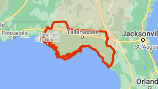
The Flash Flood Watch continues for
* Portions of southeast Alabama, Florida, and Georgia, including
the following areas, in southeast Alabama, Henry and Houston.
In Florida, Calhoun, Coastal Bay, Coastal Dixie, Coastal
Franklin, Coastal Gulf, Coastal Jefferson, Coastal Taylor,
Coastal Wakulla, Gadsden, Inland Bay, Inland Dixie, Inland
Franklin, Inland Gulf, Inland Jefferson, Inland Taylor, Inland
Wakulla, Jackson, Lafayette, Leon, Liberty, Madison, and
Washington. In Georgia, Baker, Ben Hill, Berrien, Brooks,
Calhoun, Clay, Colquitt, Cook, Decatur, Dougherty, Early,
Grady, Irwin, Lanier, Lee, Lowndes, Miller, Mitchell, Quitman,
Randolph, Seminole, Terrell, Thomas, Tift, Turner, and Worth.
* Through this evening
* Pockets of heavy rain will spread into the Florida Big Bend and
lower I-75 corridor of Georgia today. Storm total rainfall of 1
to 3 inches has already occurred over much of the area outside
of the Southeast Florida Big Bend since Friday evening.
Additional rainfall amounts of 1 to 2 inches with isolated
amounts of 3 to 4 inches are possible.
Recommended actions
A Flash Flood Watch means that conditions may develop that lead
to flash flooding. Flash flooding is a VERY DANGEROUS SITUATION.
You should monitor later forecasts and be prepared to take action
should Flash Flood Warnings be issued.
___
https://www.google.org/publicalerts/alert?aid=3430f1cfd06c58ef&hl=en&gl=US&source=web