
Major Winter Storm to Bring Significant Snow, Ice from Texas to Northeast into Early Next Week
By Jonathan Erdman
The Weather Channel
At a Glance
- A major winter storm is expected late this weekend into early week.
- A large part of the South is expected to see accumulating snow early next week.
- The snow will fall deep into Texas, Louisiana and Mississippi.
- This system may also bring yet more snow and ice to parts of the Midwest and East.
Winter Storm Uri is likely to bury parts of the South with significant snow and ice early next week before moving into the snow-fatigued Midwest and East.
This storm has been named Winter Storm Uri by The Weather Channel.
This winter storm will bring considerably worse weather conditions than what we saw early Thursday morning, which resulted in a pileup of more than 130 vehicles and at least six deaths.
(MORE: Dual Winter Storms Knock Out Power To 700,000 on East and West Coasts)
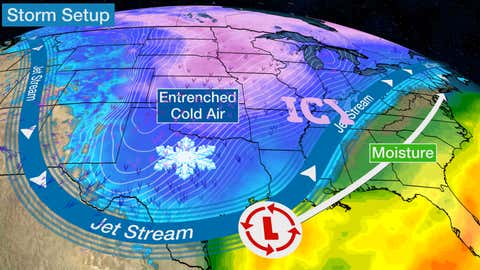
Winter Storm Setup
A powerful southward plunge of the jet stream will pivot out of the southern Rockies across the South this weekend. Low pressure at the surface will track out of the Gulf of Mexico generally toward the northeast, wrapping moisture into the cold air.
Bitterly cold air in the Plains will only be reinforced this weekend smashing records as far south as the Rio Grande Valley.
SPONSORED: Epic winter clearance sale at Sierra Trading Post
This will produce snow and some ice much farther south than usual – and farther south than seen on Thursday. From there, this storm could then produce significant snow and ice in parts of the Midwest and East.
Winter Storm Alerts
The National Weather Service has issued winter storm watches and warnings for parts of the Southern Rockies, Southern Plains, and Ohio Valley.
Winter storm warnings stretch from eastern Colorado and New Mexico through all of Oklahoma and Arkansas and into Texas, Louisiana, Mississippi and Tennessee.
These warnings mean a combination of blowing snow, gusty winds and bitterly cold temperatures across the Southern Plains will create conditions that will make it dangerous to be outside and to drive on.

(Issued by the National Weather Service)
Let’s start by laying out the timing, then discuss in general terms how much snow may fall.
Forecast Timing
Pockets of freezing rain or flurries are likely across Texas through early Sunday. This will keep roads slick well before heavier precipitation arrives on Sunday.
Sunday-Sunday Night
Snow will begin to spread into the central and southern Plains Saturday night and continue into Sunday.
Snow could become heavy at times during the day Sunday in the southern and central Plains from Kansas and Oklahoma into the Texas Panhandle and New Mexico. Accumulating snow may also reach as far east as western Missouri and Arkansas Sunday afternoon, including Dallas, Wichita and Oklahoma City, potentially leading to slippery, snow-covered roads.
Gusty winds up to 35 mph will create lower visibility conditions with frigid wind chills.
A wintry mix of snow, sleet and freezing rain is increasingly likely from San Antonio to Shreveport and Little Rock late in the day.

Sunday night, snow will expand south and east across the Mississippi and Ohio Valleys, including Dallas-Ft. Worth, St. Louis, Indianapolis and Pittsburgh.
Snow may fall as far south as Houston, where the National Weather Service is saying “frigid, life and property threatening winter weather is expected.”
A band of sleet and freezing rain will fall on the southern and eastern end of the precipitation Sunday into Sunday night in southern Texas into Louisiana and the lower-Mississippi and Tennessee valleys, including Houston and Nashville, and possibly as far south as Brownsville.

(The green shadings depict where rain is expected. Areas that are shaded blue are expected to see snow. Purple-shaded locations may see either rain or snow. Areas in pink are expected to see sleet or freezing rain (ice).)
Monday
Snow, possibly heavy, may fall Monday from eastern Texas into parts of northern Louisiana, Arkansas, and the mid-Mississippi and Ohio Valleys. Some snowfall or ice could expand as far east as the mid-Atlantic and interior Northeast.
Freezing rain and sleet may occur just to the east of the area of snow from southeast Texas and Louisiana to the Tennessee Valley and the piedmont of Virginia.
Uri will leave temperatures behind that are more akin to winter in the Dakotas. Single digit morning lows are possible across northern Texas Monday and Tuesday mornings.
By Monday night, this mess of heavy snow, freezing rain and sleet may spread across much of the Northeast and mid-Atlantic, while continuing from the Ohio Valley southward into the Tennessee and mid-Mississippi valleys.

(The green shadings depict where rain is expected. Areas that are shaded blue are expected to see snow. Purple-shaded locations may see either rain or snow. Areas in pink are expected to see sleet or freezing rain (ice).)
Tuesday
Typical of winter storm forecasts this far out in time, computer forecast models are not in sync on all the details regarding Tuesday’s forecast.
For now, most of the forecast models we examine suggest most of the wintry precipitation in the South should be largely over with by Tuesday, with the storm taking aim on parts of the Great Lakes and Northeast. Much of the I-95 corridor may see a rain/snow mix.
(MORE: Why Forecasts for Winter Storms are Typically Uncertain Many Days Out)

(The green shadings depict where rain is expected. Areas that are shaded blue are expected to see snow. Purple-shaded locations may see either rain or snow. Areas in pink are expected to see sleet or freezing rain (ice).)
How Much Snow?
Given the wealth of cold air in place mentioned earlier, many locations that are typically on the border of snow vs. rain will be solidly snow with this storm.
This includes places like Dallas-Ft. Worth, which could easily pick up several inches of snow. This will likely be the first snowfall at Dallas-Ft. Worth International Airport with an inch or more of snow, since early March 2015.
Accumulating snow is also of higher confidence in Austin, Texas; Shreveport, Louisiana; and Memphis, Tennessee.
In fact, some light accumulations are even possible as far south as San Antonio, Houston and Jackson, Mississippi. The last time measurable snow fell at Houston’s Hobby Airport was Dec. 7-8, 2017.
Heavier snow accumulations are most likely from Oklahoma and the Texas Panhandle into parts of New Mexico. It’s been 10 years since Oklahoma City’s Will Rogers Airport had at least a 6-inch two-day snowstorm, which was the infamous Groundhog 2011 Plains to Great Lakes blizzard.
Some heavier snowfall may also occur in the lower-Mississippi and Ohio valleys. We’ll talk about those prospects in the next section.

There is also a threat of accumulating ice from parts of central and southeast Texas into Louisiana, Mississippi, northern and western Alabama, Tennessee, Kentucky, then into parts of the Ohio Valley and East.
A glaze of ice is possible as far south as the Texas Coast, including Houston and Corpus Christi.
A significant icing is possible from central Louisiana to eastern Kentucky, with more than a quarter-inch of ice possible.

And if this all isn’t enough, a second snow and ice event is possible around the middle of next week in parts of South, possibly in areas hit by this first storm.
(MAPS: 7-Day U.S. Rain/Snow Forecasts)
Those with any travel plans in the southern Plains and Mid-South regions early next week may want to either have alternate plans or cancel those plans, as roads across this region will likely become dangerous, if not impassable, if this forecast holds.
If travel must be done this weekend into early next weekend, be prepared for frigid temperatures and a lack of heat in the case of car issues. Pack a kit with blankets, hand warmers and hats to keep you warm.
Northeast Outlook
As Uri moves through the Ohio Valley and Northeast beginning late Sunday and ending late Tuesday, it will drop a streak of heavy, wet snow across the region.
Many areas will see more than five inches of snow away from the Atlantic coast. The Interstate 95 corridor should be largely accumulation-free south of Boston, but a rain/snow mix is likely from Boston to New York, and further south in the mid-Atlantic where slush may pile up.

Check back to weather.com for updates and potential changes as key details become clearer in the coming days.
___
https://weather.com/storms/winter/news/2021-02-10-south-snow-texas-midwest-east